


NHC Offshore Waters Forecasts
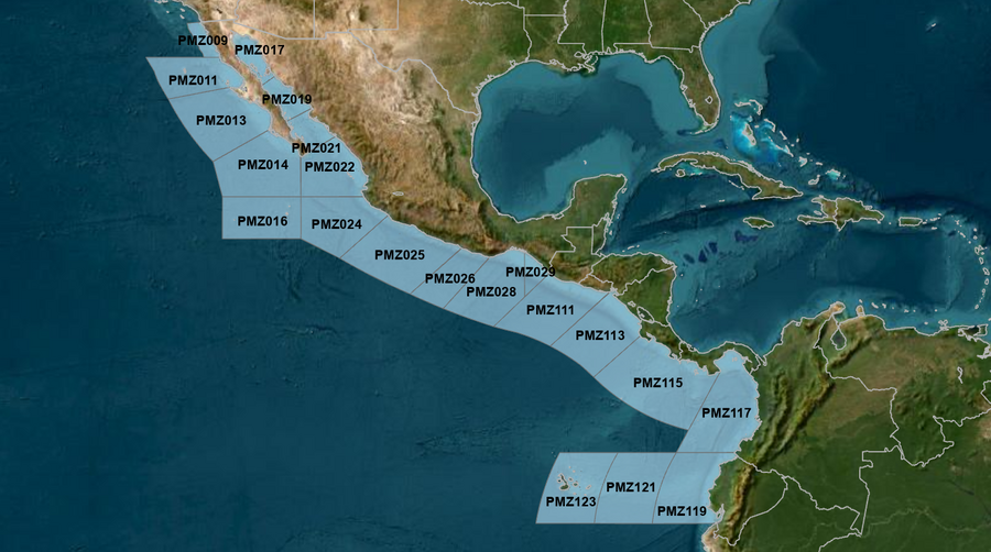
Hover to view popup zone forecast; click a zone to view related text forecast below. Show All Text Below
East Pacific within 250 nm of Mexico (OFFPZ7)
571
FZPN27 KNHC 112127
OFFPZ7

Offshore Waters Forecast
NWS National Hurricane Center Miami, FL
227 PM PDT Sun May 11 2025

Offshore Waters Forecast for the E Pacific within 250 nm of
Mexico

Seas given as significant wave height, which is the average
height of the highest 1/3 of the waves. Individual waves may be
more than twice the significant wave height.
Synopsis for the E Pacific within 250 nm of Mexico
PMZ001-120930-
Synopsis for the E Pacific within 250 nm of Mexico
227 PM PDT Sun May 11 2025

.SYNOPSIS...A recent scatterometer pass depicted gale force N
winds across the Tehuantepec region N of 15N, with a plume of
fresh to strong NE to E extending SW to near 100W. Seas are 10 to
13 ft with the strongest winds, with an area of seas in excess
of 8 ft covering the waters from 11N to 14N between 94W and 100W.
Minimal gale force winds associated with this late season gap
wind event will continue through Mon morning. A plume of seas in
the 8 to 9 ft range will persist a little longer. Elsewhere, a
weak cold front will move into Baja California Norte by late Tue,
then dissipate. High pressure building behind the front will
enhance the NW winds to fresh conditions west of the Baja
California peninsula, along with large NW swell. Seas of 6 to 9
ft are expected N of Punta Eugenia Tue night into Wed. Moderate
or weaker winds and moderate seas, primarily in SW swell, will
prevail elsewhere.
PMZ009 Zone Forecast
PMZ009-120930-
Mexico Border S to 30N within 60 nm of shore-
227 PM PDT Sun May 11 2025

.TONIGHT...NW to N winds 10 to 15 kt. Seas 4 to 6 ft in NW
swell. Period 15 seconds.
.MON...NW winds 15 to 20 kt. Seas 5 to 7 ft. Period 14 seconds.
.MON NIGHT...NW winds 10 to 15 kt N of 31N, and NW 15 to 20 kt S
of 31N. Seas 5 to 7 ft. Period 15 seconds.
.TUE...NW winds 15 to 20 kt N of 31N, and NW to N 15 to 20 kt S
of 31N. Seas 5 to 7 ft. Period 17 seconds.
.TUE NIGHT...NW winds 15 to 20 kt. Seas 6 to 8 ft in NW swell.
Period 13 seconds.
.WED...W to NW winds 10 to 15 kt N of 31N, and NW 15 to 20 kt S
of 31N. Seas 6 to 8 ft in NW swell. Period 11 seconds.
.WED NIGHT...NW winds 10 to 15 kt. Seas 6 to 8 ft in NW swell.
Period 12 seconds.
.THU...NW winds 10 to 15 kt. Seas 5 to 7 ft in NW swell. Period
13 seconds.
.THU NIGHT...NW winds 10 to 15 kt. Seas 5 to 7 ft in NW swell.
Period 13 seconds.
.FRI...NW winds 10 kt. Seas 5 to 7 ft in NW swell. Period
17 seconds.
.FRI NIGHT...NW winds 10 to 15 kt. Seas 4 to 6 ft. Period
17 seconds.
Forecaster GR
PMZ011 Zone Forecast
PMZ011-120930-
30N to Punta Eugenia within 250 nm of shore-
227 PM PDT Sun May 11 2025

.TONIGHT...NW to N winds 10 to 15 kt. Seas 5 to 7 ft in NW
swell. Period 15 seconds.
.MON...NW to N winds 15 to 20 kt. Seas 5 to 7 ft in NW swell.
Period 14 seconds.
.MON NIGHT...NW to N winds 15 to 20 kt. Seas 5 to 7 ft. Period
17 seconds.
.TUE...NW to N winds 15 to 20 kt. Seas 5 to 7 ft. Period
16 seconds.
.TUE NIGHT...NW to N winds 15 to 20 kt. Seas 6 to 9 ft in NW
swell. Period 12 seconds.
.WED...NW to N winds 15 to 20 kt. Seas 6 to 9 ft in NW swell.
Period 11 seconds.
.WED NIGHT...NW winds 15 to 20 kt. Seas 6 to 9 ft in NW swell.
Period 11 seconds.
.THU...NW winds 15 kt. Seas 6 to 9 ft in NW swell. Period
12 seconds.
.THU NIGHT...NW winds 15 kt. Seas 6 to 8 ft in NW swell. Period
13 seconds.
.FRI...NW winds 10 to 15 kt. Seas 6 to 8 ft in NW swell. Period
14 seconds.
.FRI NIGHT...NW winds 10 to 15 kt. Seas 5 to 7 ft in NW swell.
Period 15 seconds.
Forecaster GR
PMZ013 Zone Forecast
PMZ013-120930-
Punta Eugenia to Cabo San Lazaro within 250 nm offshore-
227 PM PDT Sun May 11 2025

.TONIGHT...NW winds 10 to 15 kt. Seas 3 to 5 ft. Period
14 seconds.
.MON...NW to N winds 10 to 15 kt. Seas 4 to 6 ft. Period
15 seconds.
.MON NIGHT...NW to N winds 10 to 15 kt. Seas 4 to 6 ft. Period
17 seconds.
.TUE...NW to N winds 10 to 15 kt. Seas 5 to 7 ft in NW swell.
Period 16 seconds.
.TUE NIGHT...NW to N winds 15 to 20 kt. Seas 5 to 7 ft. Period
12 seconds.
.WED...NW to N winds 15 to 20 kt. Seas 6 to 8 ft in NW swell.
Period 12 seconds.
.WED NIGHT...NW to N winds 15 to 20 kt. Seas 6 to 8 ft in NW
swell. Period 12 seconds.
.THU...NW to N winds 15 to 20 kt. Seas 6 to 8 ft in NW swell.
Period 12 seconds.
.THU NIGHT...NW to N winds 15 to 20 kt. Seas 6 to 8 ft in NW
swell. Period 15 seconds.
.FRI...NW to N winds 10 to 15 kt. Seas 6 to 8 ft in NW swell.
Period 16 seconds.
.FRI NIGHT...NW winds 15 to 20 kt. Seas 5 to 7 ft. Period
15 seconds.
Forecaster GR
PMZ014 Zone Forecast
PMZ014-120930-
Cabo San Lazaro to Cabo San Lucas within 350 nm offshore N of
20N-
227 PM PDT Sun May 11 2025

.TONIGHT...NW winds 10 kt. Seas 3 to 5 ft. Period 14 seconds.
.MON...W to NW winds 10 kt N of 22N, and variable less than 5 kt
S of 22N. Seas 3 to 5 ft. Period 17 seconds.
.MON NIGHT...W to NW winds 10 kt N of 22N, and variable less
than 5 kt S of 22N. Seas 3 to 5 ft. Period 17 seconds.
.TUE...NW winds 10 kt. Seas 3 to 5 ft. Period 16 seconds.
.TUE NIGHT...NW winds 10 to 15 kt. Seas 4 to 6 ft. Period
14 seconds.
.WED...NW to N winds 10 to 15 kt. Seas 5 to 7 ft in NW swell.
Period 13 seconds.
.WED NIGHT...NW to N winds 15 kt. Seas 5 to 7 ft in NW swell.
Period 15 seconds.
.THU...NW to N winds 15 to 20 kt. Seas 6 to 8 ft in NW swell.
Period 15 seconds.
.THU NIGHT...NW to N winds 15 to 20 kt. Seas 6 to 8 ft in NW
swell. Period 17 seconds.
.FRI...NW to N winds 15 to 20 kt. Seas 6 to 8 ft in NW swell.
Period 16 seconds.
.FRI NIGHT...NW to N winds 15 kt. Seas 5 to 7 ft in NW swell.
Period 15 seconds.
Forecaster GR
PMZ016 Zone Forecast
PMZ016-120930-
From 17N to 20N Between 110W and 115W including the
Revillagigedo Islands-
227 PM PDT Sun May 11 2025

.TONIGHT...E of 113W, W to NW winds 10 kt late.
Variable winds less than 5 kt in the evening. W of 113W,
variable winds less than 5 kt. Seas 3 to 5 ft. Period
15 seconds.
.MON...Variable winds less than 5 kt. Seas 3 to 5 ft in NW
swell. Period 17 seconds.
.MON NIGHT...Variable winds less than 5 kt. Seas 3 to 5 ft in NW
swell. Period 16 seconds.
.TUE...Variable winds less than 5 kt, becoming NW to N 10 kt in
the afternoon. Seas 3 to 5 ft in NW swell. Period 15 seconds.
.TUE NIGHT...NW to N winds 10 kt. Seas 3 to 5 ft. Period
14 seconds.
.WED...NW to N winds 10 to 15 kt. Seas 3 to 5 ft. Period
15 seconds.
.WED NIGHT...N winds 10 to 15 kt. Seas 4 to 6 ft. Period
17 seconds.
.THU...N winds 10 to 15 kt. Seas 5 to 7 ft in W to NW swell.
Period 17 seconds.
.THU NIGHT...N winds 10 to 15 kt. Seas 5 to 7 ft in NW swell.
Period 16 seconds.
.FRI...N winds 10 to 15 kt. Seas 6 to 8 ft in NW swell. Period
15 seconds.
.FRI NIGHT...N winds 10 to 15 kt. Seas 5 to 7 ft in NW swell.
Period 14 seconds.
Forecaster GR
PMZ017 Zone Forecast
PMZ017-120930-
Northern Gulf of California-
227 PM PDT Sun May 11 2025

.TONIGHT...S winds 10 to 15 kt. Seas 3 ft or less. Period
4 seconds.
.MON...SE to S winds 10 to 15 kt. Seas 2 to 4 ft. Period
5 seconds.
.MON NIGHT...S to SW winds 10 to 15 kt. Seas 2 to 4 ft. Period
5 seconds.
.TUE...SE to S winds 10 to 15 kt. Seas 2 to 4 ft. Period
5 seconds.
.TUE NIGHT...SW to W winds 15 to 20 kt. Seas 2 to 4 ft. Period
4 seconds.
.WED...NW winds 10 to 15 kt. Seas 2 to 4 ft. Period 4 seconds.
.WED NIGHT...SW winds 10 kt. Seas 3 ft or less. Period
3 seconds.
.THU...S to SW winds 10 kt. Seas 3 ft or less. Period 3 seconds.
.THU NIGHT...S to SW winds 10 to 15 kt. Seas 3 ft or less.
Period 3 seconds.
.FRI...S to SW winds 10 kt. Seas 3 ft or less. Period 3 seconds.
.FRI NIGHT...S winds 10 to 15 kt. Seas 3 ft or less. Period
5 seconds.
Forecaster GR
PMZ019 Zone Forecast
PMZ019-120930-
Central Gulf of California-
227 PM PDT Sun May 11 2025

.TONIGHT...SE to S winds 10 to 15 kt. Seas 3 ft or less. Period
14 seconds.
.MON...SE to S winds 10 to 15 kt. Seas 3 ft or less. Period
13 seconds.
.MON NIGHT...SE to S winds 10 to 15 kt. Seas 3 ft or less.
Period 4 seconds.
.TUE...SE to S winds 10 to 15 kt. Seas 3 ft or less. Period
4 seconds.
.TUE NIGHT...S winds 10 kt. Seas 3 ft or less. Period 4 seconds.
.WED...NW winds 10 kt. Seas 3 ft or less. Period 6 seconds.
.WED NIGHT...NW winds 10 to 15 kt. Seas 3 ft or less. Period
3 seconds.
.THU...NW winds 10 kt. Seas 3 ft or less. Period 4 seconds.
.THU NIGHT...W to NW winds 10 to 15 kt. Seas 3 ft or less.
Period 4 seconds.
.FRI...NW winds 10 to 15 kt. Seas 3 ft or less. Period
14 seconds.
.FRI NIGHT...W winds 10 kt. Seas 3 ft or less. Period
13 seconds.
Forecaster GR
PMZ021 Zone Forecast
PMZ021-120930-
Southern Gulf of California-
227 PM PDT Sun May 11 2025

.TONIGHT...S winds 10 kt. Seas 3 ft or less. Period 14 seconds.
.MON...SE to S winds 10 kt. Seas 3 ft or less. Period
14 seconds.
.MON NIGHT...SE to S winds 10 to 15 kt. Seas 3 ft or less.
Period 17 seconds.
.TUE...SE to S winds 10 kt. Seas 3 ft or less. Period
16 seconds.
.TUE NIGHT...S winds 10 to 15 kt. Seas 3 ft or less. Period
13 seconds.
.WED...S winds 10 kt. Seas 3 ft or less. Period 12 seconds.
.WED NIGHT...W to NW winds 10 kt. Seas 3 ft or less. Period
12 seconds.
.THU...NW winds 10 kt. Seas 2 to 4 ft. Period 14 seconds.
.THU NIGHT...W to NW winds 10 to 15 kt. Seas 2 to 4 ft. Period
14 seconds.
.FRI...NW winds 10 to 15 kt. Seas 3 to 5 ft. Period 14 seconds.
.FRI NIGHT...W to NW winds 10 to 15 kt. Seas 3 to 5 ft. Period
13 seconds.
Forecaster GR
PMZ022 Zone Forecast
PMZ022-120930-
N of 20N E of 110W to the Entrance of the Gulf of California-
227 PM PDT Sun May 11 2025

.TONIGHT...W to NW winds 10 kt in the evening, becoming variable
winds less than 5 kt. Seas 2 to 4 ft. Period 14 seconds.
.MON...SW to W winds 10 kt. Seas 2 to 4 ft. Period 17 seconds.
.MON NIGHT...W winds 10 kt. Seas 2 to 4 ft. Period 17 seconds.
.TUE...W winds 10 to 15 kt. Seas 2 to 4 ft. Period 16 seconds.
.TUE NIGHT...W to NW winds 10 to 15 kt. Seas 3 to 5 ft. Period
15 seconds.
.WED...W to NW winds 10 to 15 kt. Seas 3 to 5 ft. Period
14 seconds.
.WED NIGHT...W to NW winds 10 to 15 kt. Seas 4 to 6 ft. Period
15 seconds.
.THU...NW to N winds 10 to 15 kt. Seas 5 to 7 ft in SW swell.
Period 17 seconds.
.THU NIGHT...NW winds 10 to 15 kt. Seas 5 to 7 ft in SW to W
swell. Period 17 seconds.
.FRI...NW winds 10 to 15 kt. Seas 5 to 7 ft in SW swell. Period
16 seconds.
.FRI NIGHT...NW winds 15 to 20 kt. Seas 5 to 7 ft. Period
15 seconds.
Forecaster GR
PMZ024 Zone Forecast
PMZ024-120930-
Colima and Jalisco within 300 nm offshore S of 20N and E of
110W-
227 PM PDT Sun May 11 2025

.TONIGHT...Variable winds less than 5 kt, becoming NW to N 10 kt
late. Seas 2 to 4 ft. Period 13 seconds.
.MON...NW winds 10 kt. Seas 3 to 5 ft. Period 17 seconds.
.MON NIGHT...NW winds 10 kt. Seas 3 to 5 ft. Period 17 seconds.
.TUE...NW to N winds 10 to 15 kt. Seas 3 to 5 ft. Period
16 seconds.
.TUE NIGHT...NW winds 10 to 15 kt. Seas 3 to 5 ft. Period
14 seconds.
.WED...NW winds 10 to 15 kt. Seas 3 to 5 ft. Period 14 seconds.
.WED NIGHT...NW winds 15 to 20 kt. Seas 5 to 7 ft. Period
16 seconds.
.THU...NW winds 10 to 15 kt. Seas 5 to 7 ft in SW swell. Period
18 seconds.
.THU NIGHT...NW winds 10 to 15 kt. Seas 5 to 7 ft in SW to W
swell. Period 17 seconds.
.FRI...NW to N winds 10 to 15 kt. Seas 5 to 7 ft in W swell.
Period 15 seconds.
.FRI NIGHT...NW winds 10 to 15 kt. Seas 5 to 7 ft in W to NW
swell. Period 15 seconds.
Forecaster GR
PMZ025 Zone Forecast
PMZ025-120930-
Michoacan and Guerrero within 250 nm offshore-
227 PM PDT Sun May 11 2025

.TONIGHT...W winds 10 kt in the evening, becoming variable winds
less than 5 kt. Seas 5 to 7 ft in W to NW swell. Period
13 seconds.
.MON...NW to N winds 10 to 15 kt. Seas 5 to 7 ft in NW swell.
Period 18 seconds.
.MON NIGHT...NW winds 10 kt. Seas 4 to 6 ft in W swell. Period
17 seconds.
.TUE...NW winds 10 to 15 kt. Seas 4 to 6 ft. Period 16 seconds.
.TUE NIGHT...W to NW winds 10 to 15 kt. Seas 4 to 6 ft. Period
14 seconds.
.WED...W to NW winds 10 to 15 kt. Seas 4 to 6 ft. Period
14 seconds.
.WED NIGHT...W to NW winds 15 to 20 kt. Seas 5 to 7 ft. Period
16 seconds.
.THU...W to NW winds 10 kt. Seas 5 to 7 ft in S to SW swell.
Period 18 seconds.
.THU NIGHT...W to NW winds 10 to 15 kt. Seas 5 to 7 ft in S to
SW swell. Period 16 seconds.
.FRI...Variable winds less than 5 kt. Seas 5 to 7 ft in S to SW
swell. Period 15 seconds.
.FRI NIGHT...W winds 10 kt. Seas 5 to 7 ft in S to SW swell.
Period 15 seconds.
Forecaster GR
PMZ026 Zone Forecast
PMZ026-120930-
Oaxaca W of Puerto Angel within 250 nm offshore-
227 PM PDT Sun May 11 2025

.TONIGHT...N of 14N, S to SW winds 10 kt, shifting to NW to N
late. S of 14N, E winds 15 to 20 kt. Seas 6 to 9 ft in
E swell. Period 14 seconds.
.MON...N to NE winds 10 to 15 kt, shifting to W in the
afternoon. Seas 5 to 7 ft in E swell. Period 18 seconds.
Scattered showers and isolated tstms through the day.
.MON NIGHT...NW to N winds 10 to 15 kt. Seas 5 to 7 ft in E to
SE swell. Period 17 seconds.
.TUE...NW winds 10 to 15 kt. Seas 3 to 5 ft. Period 16 seconds.
.TUE NIGHT...NW winds 10 to 15 kt. Seas 3 to 5 ft. Period
15 seconds.
.WED...W to NW winds 10 to 15 kt. Seas 3 to 5 ft. Period
14 seconds.
.WED NIGHT...W to NW winds 10 kt. Seas 4 to 6 ft in S to SW
swell. Period 16 seconds.
.THU...W to NW winds 10 kt. Seas 4 to 6 ft in S to SW swell.
Period 18 seconds.
.THU NIGHT...W winds 10 kt. Seas 5 to 7 ft in S to SW swell.
Period 16 seconds.
.FRI...W to NW winds 10 kt. Seas 5 to 7 ft in S to SW swell.
Period 16 seconds.
.FRI NIGHT...W winds 10 kt. Seas 5 to 7 ft in S to SW swell.
Period 15 seconds.
Forecaster GR
PMZ028 Zone Forecast
PMZ028-120930-
Oaxaca E of Puerto Angel within 300 nm offshore including the
Gulf of Tehuantepec-
227 PM PDT Sun May 11 2025

...GALE WARNING...

.TONIGHT...N winds 25 to 35 kt N of 14N, and NE 20 to 25 kt S of
14N. Seas 8 to 12 ft in N to NE swell. Period 11 seconds.
.MON...NE winds 25 to 35 kt, becoming N to NE 15 to 25 kt in the
afternoon. Seas 7 to 10 ft in N to NE swell. Period 18 seconds.
.MON NIGHT...NW winds 15 to 20 kt N of 14N, and N to NE 10 kt S
of 14N. Seas 5 to 7 ft. Period 17 seconds.
.TUE...NW winds 10 to 15 kt. Seas 3 to 5 ft. Period 17 seconds.
.TUE NIGHT...NW winds 10 to 15 kt. Seas 3 to 5 ft. Period
15 seconds.
.WED...W to NW winds 10 kt. Seas 3 to 5 ft. Period 14 seconds.
.WED NIGHT...W winds 10 kt. Seas 3 to 5 ft. Period 16 seconds.
.THU...W to NW winds 10 kt. Seas 4 to 6 ft in S to SW swell.
Period 18 seconds.
.THU NIGHT...SW to W winds 10 kt. Seas 5 to 7 ft in S to SW
swell. Period 17 seconds.
.FRI...W winds 10 kt. Seas 5 to 7 ft in S to SW swell. Period
16 seconds.
.FRI NIGHT...SW to W winds 10 kt. Seas 5 to 7 ft in S to SW
swell. Period 15 seconds.
Forecaster GR
PMZ029 Zone Forecast
PMZ029-120930-
Offshore Chiapas E of 94W-
227 PM PDT Sun May 11 2025

.TONIGHT...E of 93W, variable winds less than 5 kt. W of 93W, S
winds 10 kt, shifting to NW to N 15 to 20 kt late.
Seas 6 to 8 ft in W to NW swell. Period 14 seconds.
.MON...E of 93W, variable winds less than 5 kt in the morning.
Variable winds less than 5 kt in the afternoon. W of 93W, N to
NE winds 10 kt in the morning. Seas 5 to 7 ft in NW swell.
Period 13 seconds.
.MON NIGHT...W to NW winds 10 to 15 kt. Seas 4 to 6 ft in W to
NW swell. Period 18 seconds.
.TUE...N to NE winds 10 kt, shifting to SW in the afternoon.
Seas 3 to 5 ft. Period 17 seconds.
.TUE NIGHT...NW winds 10 kt. Seas 2 to 4 ft. Period 15 seconds.
.WED...Variable winds less than 5 kt E of 93W, and W to NW 10 kt
W of 93W. Seas 2 to 4 ft. Period 15 seconds.
.WED NIGHT...Variable winds less than 5 kt. Seas 3 to 5 ft in SW
swell. Period 15 seconds.
.THU...Variable winds less than 5 kt. Seas 3 to 5 ft in S to SW
swell. Period 18 seconds.
.THU NIGHT...Variable winds less than 5 kt. Seas 4 to 6 ft in S
to SW swell. Period 17 seconds.
.FRI...Variable winds less than 5 kt. Seas 4 to 6 ft in S to SW
swell. Period 16 seconds.
.FRI NIGHT...Variable winds less than 5 kt. Seas 4 to 6 ft in S
to SW swell. Period 16 seconds.
Forecaster GR
East Pacific offshore of Central America, Colombia, & Ecuador (OFFPZ8)
212
FZPN28 KNHC 112128
OFFPZ8

Offshore Waters Forecast
NWS National Hurricane Center Miami, FL
228 PM PDT Sun May 11 2025

Offshore Waters Forecast for the E Pacific within 250 nm of
Central America, Colombia, and within 750 nm of Ecuador

Seas given as significant wave height, which is the average
height of the highest 1/3 of the waves. Individual waves may be
more than twice the significant wave height.
Synopsis for the E Pacific within 250 nm of Central America, Colombia, and within 750 nm of Ecuador
PMZ101-120930-
Synopsis for the E Pacific within 250 nm of Central America,
Colombia, and within 750 nm of Ecuador
228 PM PDT Sun May 11 2025

.SYNOPSIS...Moderate to fresh NE to E winds are expected in the
Papagayo region most of the forecast period, increasing to fresh
to strong speeds at night from Sun night through mid week.
Elsewhere mainly light to gentle winds are expected through early
this week, except between Ecuador and the Galapagos Islands
where gentle to moderate southerly winds will persist. Seas
generated in the Tehuantepec region will continue to propagate
across the western offshore waters off Guatemala tonight. Slight
to moderate seas, primarily in SW swell, will prevail elsewhere
through the middle of the week. Looking ahead, expect moderate to
rough seas, in long period SW swell, between Ecuador and the
Galapagos Islands Wed through Fri.
PMZ111 Zone Forecast
PMZ111-120930-
Guatemala and El Salvador to 250 nm offshore-
228 PM PDT Sun May 11 2025

.TONIGHT...N winds 10 kt. Seas 6 to 8 ft in NW swell. Period
14 seconds.
.MON...NE to E winds 10 kt. Seas 5 to 7 ft in NW swell. Period
18 seconds.
.MON NIGHT...NW to N winds 10 kt. Seas 5 to 7 ft in NW swell.
Period 18 seconds. Scattered showers and isolated tstms through
the night.
.TUE...N to NE winds 10 kt, shifting to E in the afternoon.
Seas 4 to 6 ft in SW to W swell. Period 17 seconds. Scattered
showers and isolated tstms through the day.
.TUE NIGHT...NW winds 10 kt. Seas 4 to 6 ft in SE to S swell.
Period 15 seconds.
.WED...NW to N winds 10 kt. Seas 3 to 5 ft. Period 14 seconds.
.WED NIGHT...Variable winds less than 5 kt. Seas 4 to 6 ft in S
to SW swell. Period 16 seconds.
.THU...NE winds 10 kt. Seas 4 to 6 ft in S to SW swell. Period
17 seconds.
.THU NIGHT...S winds 10 kt. Seas 5 to 7 ft in S to SW swell.
Period 17 seconds.
.FRI...S winds 10 kt. Seas 5 to 7 ft in S to SW swell. Period
16 seconds.
.FRI NIGHT...S to SW winds 15 to 20 kt. Seas 6 to 9 ft in S to
SW swell. Period 15 seconds.
Forecaster GR
PMZ113 Zone Forecast
PMZ113-120930-
El Salvador to North Costa Rica including the Gulfs of Fonseca
and Papagayo-
228 PM PDT Sun May 11 2025

.TONIGHT...NE to E winds 20 to 25 kt Offshore Gulf of Papagayo,
and NE 15 to 20 kt Elsewhere. Seas 5 to 7 ft. Period 14 seconds.
Scattered showers and isolated tstms through the night.
.MON...NE to E winds 15 to 20 kt. Seas 5 to 7 ft in NE swell.
Period 17 seconds. Scattered showers and isolated tstms through
the day.
.MON NIGHT...NE to E winds 20 to 25 kt Offshore Gulf of Papagayo,
and NE 15 to 20 kt Elsewhere. Seas 5 to 7 ft. Period 18 seconds.
Scattered showers and isolated tstms through the night.
.TUE...NE winds 15 to 20 kt. Seas 5 to 7 ft in NE to E swell.
Period 17 seconds. Scattered showers and isolated tstms through
the day.
.TUE NIGHT...NE to E winds 20 to 25 kt Offshore Gulf of Papagayo,
and NE 15 to 20 kt Elsewhere. Seas 5 to 7 ft. Period 13 seconds.
.WED...NE winds 15 to 20 kt. Seas 4 to 6 ft. Period 14 seconds.
.WED NIGHT...E winds 10 to 15 kt. Seas 4 to 6 ft. Period
16 seconds.
.THU...E winds 10 to 15 kt. Seas 5 to 7 ft in S to SW swell.
Period 16 seconds.
.THU NIGHT...E to SE winds 15 to 20 kt. Seas 5 to 7 ft. Period
16 seconds.
.FRI...SE to S winds 15 to 20 kt. Seas 6 to 9 ft in S to SW
swell. Period 16 seconds.
.FRI NIGHT...S to SW winds 15 to 20 kt. Seas 6 to 9 ft in S to
SW swell. Period 15 seconds.
Forecaster GR
PMZ115 Zone Forecast
PMZ115-120930-
North Costa Rica to West Panama to 250 nm offshore-
228 PM PDT Sun May 11 2025

.TONIGHT...Variable winds less than 5 kt. Seas 3 to 5 ft in S to
SW swell. Period 14 seconds. Scattered showers and isolated
tstms through the night.
.MON...Variable winds less than 5 kt, becoming SW to W 10 kt in
the afternoon. Seas 3 to 5 ft in S to SW swell. Period
16 seconds. Scattered showers and isolated tstms through the
day.
.MON NIGHT...SW to W winds 10 kt. Seas 3 to 5 ft. Period
18 seconds. Scattered showers and isolated tstms through the
night.
.TUE...SW to W winds 10 to 15 kt. Seas 4 to 6 ft. Period
17 seconds. Numerous showers and scattered tstms.
.TUE NIGHT...SW to W winds 10 to 15 kt. Seas 4 to 6 ft. Period
15 seconds.
.WED...SW winds 10 to 15 kt. Seas 4 to 6 ft. Period 15 seconds.
.WED NIGHT...SW winds 10 to 15 kt. Seas 5 to 7 ft in S to SW
swell. Period 16 seconds.
.THU...Variable winds less than 5 kt Near the Azuero Peninsula,
and S to SW 15 to 20 kt Elsewhere. Seas 5 to 7 ft. Period
16 seconds.
.THU NIGHT...Variable winds less than 5 kt Near the Azuero
Peninsula, and SW to W 10 to 15 kt Elsewhere. Seas 5 to 7 ft in
S to SW swell. Period 16 seconds.
.FRI...Variable winds less than 5 kt Near the Azuero Peninsula,
and SW 10 to 15 kt Elsewhere. Seas 5 to 7 ft in S to SW swell.
Period 15 seconds.
.FRI NIGHT...SW to W winds 10 to 15 kt. Seas 5 to 7 ft in S to
SW swell. Period 15 seconds.
Forecaster GR
PMZ117 Zone Forecast
PMZ117-120930-
East Panama and Colombia including the Gulf of Panama-
228 PM PDT Sun May 11 2025

.TONIGHT...Variable winds less than 5 kt. Seas 3 to 5 ft in S to
SW swell. Period 14 seconds. Scattered showers and isolated
tstms through the night.
.MON...Gulf of Panama, N winds 10 kt in the morning, becoming
variable winds less than 5 kt. Elsewhere, S to SW winds 10 kt.
Seas 3 to 5 ft. Period 14 seconds. Scattered showers and
isolated tstms through the day.
.MON NIGHT...SW winds 10 to 15 kt. Seas 3 to 5 ft. Period
18 seconds. Scattered tstms through the night.
.TUE...SW winds 10 to 15 kt. Seas 4 to 6 ft. Period 18 seconds.
Numerous showers and scattered tstms through the day.
.TUE NIGHT...SW winds 10 kt Gulf of Panama, and SW 15 to 20 kt
Elsewhere. Seas 4 to 6 ft. Period 14 seconds.
.WED...SW winds 15 to 20 kt. Seas 4 to 6 ft. Period 15 seconds.
.WED NIGHT...SW winds 10 to 15 kt. Seas 4 to 6 ft. Period
17 seconds.
.THU...SW winds 10 to 15 kt. Seas 5 to 7 ft in S to SW swell.
Period 16 seconds.
.THU NIGHT...SW to W winds 10 kt. Seas 5 to 7 ft in S to SW
swell. Period 16 seconds.
.FRI...S to SW winds 10 to 15 kt. Seas 6 to 8 ft in S to SW
swell. Period 16 seconds.
.FRI NIGHT...SW winds 10 kt. Seas 5 to 7 ft in S to SW swell.
Period 15 seconds.
Forecaster GR
PMZ119 Zone Forecast
PMZ119-120930-
Ecuador including the Gulf of Guayaquil to 250 nm offshore-
228 PM PDT Sun May 11 2025

.TONIGHT...Gulf of Guayaquil, SW to W winds 10 kt in the
evening, becoming variable winds less than 5 kt. Elsewhere, S to
SW winds 10 kt. Seas 4 to 6 ft in S to SW swell. Period
13 seconds.
.MON...Gulf of Guayaquil, variable winds less than 5 kt,
becoming W 10 kt in the afternoon. Elsewhere, S to SW winds
10 kt. Seas 4 to 6 ft in S to SW swell. Period 13 seconds.
.MON NIGHT...S to SW winds 10 to 15 kt. Seas 4 to 6 ft. Period
17 seconds.
.TUE...Gulf of Guayaquil, variable winds less than 5 kt,
becoming SW to W 10 kt in the afternoon. Elsewhere, S to SW
winds 10 to 15 kt. Seas 4 to 6 ft. Period 17 seconds.
.TUE NIGHT...S to SW winds 10 to 15 kt. Seas 4 to 6 ft. Period
15 seconds.
.WED...S to SW winds 10 to 15 kt. Seas 4 to 6 ft. Period
16 seconds.
.WED NIGHT...S winds 10 kt. Seas 5 to 7 ft in S to SW swell.
Period 16 seconds.
.THU...S to SW winds 10 kt. Seas 6 to 8 ft in SW swell. Period
16 seconds.
.THU NIGHT...S to SW winds 10 kt. Seas 6 to 8 ft in S to SW
swell. Period 15 seconds.
.FRI...S to SW winds 10 kt. Seas 5 to 7 ft in S to SW swell.
Period 15 seconds.
.FRI NIGHT...S to SW winds 10 kt. Seas 5 to 7 ft in S to SW
swell. Period 15 seconds.
Forecaster GR
PMZ121 Zone Forecast
PMZ121-120930-
Ecuador between 250 and 500 nm offshore-
228 PM PDT Sun May 11 2025

.TONIGHT...SE to S winds 10 kt. Seas 3 to 5 ft. Period
13 seconds.
.MON...SE to S winds 10 kt. Seas 3 to 5 ft. Period 16 seconds.
.MON NIGHT...S winds 10 to 15 kt. Seas 4 to 6 ft in S swell.
Period 16 seconds.
.TUE...S winds 10 to 15 kt. Seas 4 to 6 ft in S to SW swell.
Period 16 seconds.
.TUE NIGHT...S winds 10 to 15 kt. Seas 4 to 6 ft. Period
14 seconds.
.WED...S winds 10 to 15 kt. Seas 5 to 7 ft in S to SW swell.
Period 16 seconds.
.WED NIGHT...S winds 10 to 15 kt. Seas 6 to 8 ft in S to SW
swell. Period 17 seconds.
.THU...S winds 10 to 15 kt. Seas 6 to 8 ft in S to SW swell.
Period 16 seconds.
.THU NIGHT...S winds 10 kt. Seas 6 to 8 ft in S to SW swell.
Period 15 seconds.
.FRI...S winds 10 kt. Seas 6 to 8 ft in S to SW swell. Period
15 seconds.
.FRI NIGHT...S winds 10 kt. Seas 5 to 7 ft in S to SW swell.
Period 15 seconds.
Forecaster GR
PMZ123 Zone Forecast
PMZ123-120930-
Offshore Galapagos Islands-
228 PM PDT Sun May 11 2025

.TONIGHT...SE winds 10 kt. Seas 4 to 6 ft in W to NW swell.
Period 17 seconds.
.MON...SE to S winds 10 kt. Seas 4 to 6 ft in W to NW swell.
Period 17 seconds.
.MON NIGHT...S winds 10 kt. Seas 4 to 6 ft in W swell. Period
16 seconds.
.TUE...S winds 10 kt. Seas 4 to 6 ft in W swell. Period
15 seconds.
.TUE NIGHT...S winds 10 to 15 kt. Seas 5 to 7 ft in SW to W
swell. Period 13 seconds.
.WED...S winds 10 to 15 kt. Seas 6 to 8 ft in SW swell. Period
15 seconds.
.WED NIGHT...S winds 10 to 15 kt. Seas 6 to 8 ft in S to SW
swell. Period 16 seconds.
.THU...S winds 10 to 15 kt. Seas 6 to 8 ft in S to SW swell.
Period 16 seconds.
.THU NIGHT...S winds 10 kt. Seas 6 to 8 ft in S to SW swell.
Period 15 seconds.
.FRI...S winds 10 kt. Seas 5 to 7 ft in S to SW swell. Period
15 seconds.
.FRI NIGHT...S winds 10 kt. Seas 5 to 7 ft in S to SW swell.
Period 14 seconds.
Forecaster GR
Tropical North Atlantic High Seas (HSFAT2)
415
FZNT02 KNHC 112044
HSFAT2

HIGH SEAS FORECAST
NWS NATIONAL HURRICANE CENTER MIAMI FL
2230 UTC SUN MAY 11 2025

SUPERSEDED BY NEXT ISSUANCE IN 6 HOURS

SEAS GIVEN AS SIGNIFICANT WAVE HEIGHT...WHICH IS THE AVERAGE
HEIGHT OF THE HIGHEST 1/3 OF THE WAVES. INDIVIDUAL WAVES MAY BE
MORE THAN TWICE THE SIGNIFICANT WAVE HEIGHT.

SECURITE

ATLANTIC FROM 07N TO 31N W OF 35W INCLUDING CARIBBEAN SEA AND
GULF OF AMERICA

SYNOPSIS VALID 1800 UTC SUN MAY 11.
24 HOUR FORECAST VALID 1800 UTC MON MAY 12.
48 HOUR FORECAST VALID 1800 UTC TUE MAY 13.

.WARNINGS.

.NONE.

.SYNOPSIS AND FORECAST.

.ATLC WITHIN 21N58W TO 15N58W TO 14N53W TO 07N50W TO 08N45W TO
13N43W TO 21N58W WINDS 20 KT OR LESS. SEAS 8 TO 9 FT IN N TO NE
SWELL.
.24 HOUR FORECAST WITHIN 12N50W TO 20N64W TO 10N56W TO 07N46W TO
07N35W TO 09N35W TO 12N50W...INCLUDING IN ATLANTIC EXPOSURES AND
PASSAGES...WINDS 20 KT OR LESS. SEAS 8 FT IN N TO NE SWELL.
.48 HOUR FORECAST WITHIN 14N45W TO 18N62W TO 11N57W TO 07N49W TO
07N36W TO 09N36W TO 14N45W...INCLUDING IN ATLANTIC EXPOSURES AND
PASSAGES...WINDS 20 KT OR LESS. SEAS 8 FT IN NE SWELL.

.ATLC 12 HOUR FORECAST WITHIN 31N77W TO 31N80W TO 30N81W TO
26N80W TO 26N79W TO 28N79W TO 31N77W SE WINDS 20 TO 25 KT. SEAS
LESS THAN 8 FT.
.24 HOUR FORECAST WITHIN 31N76W TO 31N81W TO 29N81W TO 27N80W TO
29N79W TO 30N77W TO 31N76W SE TO S WINDS 20 TO 25 KT. SEAS 8 FT
IN MIXED S AND E SWELL.
.48 HOUR FORECAST WITHIN 31N74W TO 31N76W TO 30N76W TO 29N76W TO
30N75W TO 31N74W S WINDS 20 TO 25 KT. SEAS 8 FT IN MIXED E AND
SE SWELL.

.ATLC 27 HOUR FORECAST WITHIN 20.5N71W TO 20.5N71.5W TO
20.5N72.5W TO 20N72W TO 20N70.5W TO 20.5N71W E WINDS 20 TO 25 KT.
SEAS LESS THAN 8 FT.
.48 HOUR FORECAST WITHIN 20.5N71W TO 20.5N71.5W TO 20.5N72.5W TO
20N72W TO 20N70.5W TO 20.5N71W E WINDS 20 TO 25 KT. SEAS LESS
THAN 8 FT.

.CARIBBEAN WITHIN 14N70W TO 17N75W TO 17N78W TO 14N79W TO 11N76W
TO 13N69W TO 14N70W E WINDS 20 TO 25 KT. SEAS 8 TO 12 FT.
ELSEWHERE WITHIN 18N71W TO 18N77W TO 17N78W TO 11N71W TO 11N69W
TO 14N69W TO 18N71W...INCLUDING THE GULF OF VENEZUELA...E WINDS
20 TO 25 KT. SEAS LESS THAN 8 FT. REMAINDER OF AREA WITHIN
17N76W TO 17N79W TO 14N82W TO 10N79W TO 12N73W TO 13N78W TO
17N76W WINDS 20 KT OR LESS. SEAS 8 TO 11 FT IN E TO NE SWELL.
.24 HOUR FORECAST WITHIN 17N73W TO 15N78W TO 13N79W TO 11N78W TO
12N74W TO 14N71W TO 17N73W E WINDS 20 TO 25 KT. SEAS 8 TO 12 FT.
ELSEWHERE WITHIN 15N71W TO 18N71W TO 17N74W TO 11N71W TO 12N69W
TO 14N69W TO 15N71W...INCLUDING THE GULF OF VENEZUELA...E WINDS
20 TO 25 KT. SEAS LESS THAN 8 FT. REMAINDER OF AREA WITHIN 15N76W
TO 16N75W TO 16N79W TO 13N82W TO 10N78W TO 12N74W TO 15N76W
WINDS 20 KT OR LESS. SEAS 8 TO 11 FT IN NE TO E SWELL.
.48 HOUR FORECAST WITHIN 18N71W TO 18N72W TO 14N75W TO 12N74W TO
12N69W TO 14N72W TO 18N71W...INCLUDING THE GULF OF VENEZUELA...E
WINDS 20 TO 25 KT. SEAS LESS THAN 8 FT. ELSEWHERE WITHIN 15N74W
TO 14N79W TO 12N80W TO 10N78W TO 11N76W TO 13N73W TO 15N74W WINDS
20 KT OR LESS. SEAS 8 TO 10 FT IN NE TO E SWELL.

.REMAINDER OF AREA WINDS 20 KT OR LESS. SEAS LESS THAN 8 FT.

$$
.FORECASTER ADAMS. NATIONAL HURRICANE CENTER.
Tropical Northeast Pacific High Seas (HSFEP2)
000
FZPN03 KNHC 112118
HSFEP2

HIGH SEAS FORECAST
NWS NATIONAL HURRICANE CENTER MIAMI FL
2230 UTC SUN MAY 11 2025

SUPERSEDED BY NEXT ISSUANCE IN 6 HOURS

SEAS GIVEN AS SIGNIFICANT WAVE HEIGHT...WHICH IS THE AVERAGE
HEIGHT OF THE HIGHEST 1/3 OF THE WAVES. INDIVIDUAL WAVES MAY BE
MORE THAN TWICE THE SIGNIFICANT WAVE HEIGHT.

SECURITE

E PACIFIC FROM THE EQUATOR TO 30N E OF 140W AND 03.4S TO THE
EQUATOR E OF 120W

SYNOPSIS VALID 1800 UTC SUN MAY 11.
24 HOUR FORECAST VALID 1800 UTC MON MAY 12.
48 HOUR FORECAST VALID 1800 UTC TUE MAY 13.

.WARNINGS.

...GALE WARNING...
.WITHIN 30 NM OF A LINE FROM 16N95W TO 15N95W TO 14N96W...
INCLUDING THE GULF OF TEHUANTEPEC...N TO NE WINDS 30 TO 35 KT.
SEAS 10 TO 14 FT. ELSEWHERE WITHIN 60 NM OF A LINE FROM 16N95W
TO 14N96W TO 12N100W N TO NE WINDS 20 TO 30 KT. SEAS 8 TO 11 FT.
.18 HOUR FORECAST N OF 14 BETWEEN 94.5 AND 95.5W...INCLUDING THE
GULF OF TEHUANTEPEC...N TO NE WINDS 30 TO 35 KT. SEAS 8 TO 11
FT. ELSEWHERE WITHIN 45 NM OF A LINE FROM 16N95W TO 14N95.5W TO
12N99W N TO NE WINDS 20 TO 30 KT. SEAS 8 TO 10 FT.
.24 HOUR FORECAST WITHIN 30 NM OF A LINE FROM 16N95W TO 15N95W
TO 13.5N96W N TO NE WINDS 20 TO 30 KT. SEAS 8 TO 10 FT.
ELSEWHERE FROM 11N TO 13.5N BETWEEN 95W AND 99W WINDS 20 KT OR
LESS. SEAS 8 TO 9 FT PRIMARILY IN N SWELL.
.30 HOUR FORECAST N OF 15N BETWEEN 94.5W AND 95.5W...INCLUDING
THE GULF OF TEHUANTEPEC...N WINDS 20 TO 25 KT. SEAS LESS THAN 8
FT.
.42 HOUR FORECAST WINDS 20 KT OR LESS. SEAS LESS THAN 8 FT.

.SYNOPSIS AND FORECAST.

.FROM 05N TO 14N W OF 135W WINDS 20 KT OR LESS. SEAS 8 FT IN
MIXED NE AND NW SWELL.
.24 HOUR FORECAST LITTLE CHANGE.
.48 HOUR FORECAST WINDS 20 KT OR LESS. SEAS LESS THAN 8 FT.

.06 HOUR FORECAST FROM 10N TO 11.5N E OF 88W...INCLUDING THE
GULF OF PAPAGAYO...NE TO E WINDS 20 TO 25 KT. SEAS TO 8 FT.
.24 HOUR FORECAST WITHIN 15 NM OF A LINE FROM 11N86W TO
09.5N88W...INCLUDING THE GULF OF PAPAGAYO...NE TO E WINDS 20 TO
25 KT. SEAS LESS THAN 8 FT.
.3O HOUR FORECAST FROM 10N TO 11.5N E OF 89W...INCLUDING THE
GULF OF PAPAGAYO...NE TO E WINDS 20 TO 25 KT. SEAS TO 8 FT.
.48 HOUR FORECAST WITHIN 15 NM OF A LINE FROM 11N86W TO
09.5N88W...INCLUDING THE GULF OF PAPAGAYO...NE TO E WINDS 20 TO
25 KT. SEAS LESS THAN 8 FT.

.REMAINDER OF AREA WINDS 20 KT OR LESS. SEAS LESS THAN 8 FT.

CONVECTION VALID AT 2100 UTC SUN MAY 11...

.INTERTROPICAL CONVERGENCE ZONE/MONSOON TROUGH...
THE MONSOON TROUGH EXTENDS FROM A 1008 MB LOW PRESSURE LOCATED
OVER NORTHERN COLOMBIA NEAR 10N75W TO 08N100W TO 07N130W. THE
ITCZ CONTINUES FROM 07N130W TO BEYOND 05N140W. SCATTERED
MODERATE TO ISOLATED STRONG CONVECTION IS NOTED FROM 09N TO 13N
BETWEEN 95W AND 105W...AND FROM 05N TO 100N BETWEEN 110W AND
130W.

$$
.FORECASTER GR. NATIONAL HURRICANE CENTER.